Trails for everyone, forever

Home Go Hiking Hiking Guide Lower Big Quilcene River

Lower Big Quilcene River

Olympic Peninsula > Hood Canal
47.7835, -122.9651 Map & Directions
Length
12.9 miles, roundtrip
Elevation Gain
1,890 feet
Highest Point
2,943 feet
Calculated Difficulty About Calculated Difficulty
Hard
The Quilcene borders this trail for nearly its entire length. Photo by Jessica Kelley. Full-size image
  • Dogs allowed on leash
  • Established campsites
  • Good for kids
  • Old growth
  • Rivers
  • Wildflowers/Meadows

Parking Pass/Entry Fee

Northwest Forest Pass
Saved to My Backpack

The Lower Big Quilcene Trail begins just outside the Buckhorn Wilderness and follows the lower Big Quilcene River along a mostly non-technical tread for approximately 6.5 miles. The moss-lined route starts on an old road bed through younger forest and then winds past large old-growth cedars. In spring and summer, blooming rhododendrons add vibrant color to your journey. This trail is also a great choice during the fall and winter months because the trees provide shelter from precipitation. Continue reading

Rating
3.59 out of 5

(17 votes) Log in to rate

Hiking Lower Big Quilcene River

The Lower Big Quilcene Trail begins just outside the Buckhorn Wilderness and follows the lower Big Quilcene River along a mostly non-technical tread for approximately 6.5 miles. The moss-lined route starts on an old roadbed through younger forest and then winds past large old-growth cedars. In spring and summer, blooming rhododendrons add vibrant color to your journey. This trail is also a great choice during the fall and winter months because the trees provide shelter from precipitation.

At 2.7 miles from the trailhead, you’ll encounter the first established campsite, Bark Shanty. It is a large, level camping area nestled in a grove of big trees, right on the banks of the Big Quilcene River, with plenty of room for at least half-dozen tents.

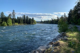
Immediately after Bark Shanty you cross the Quilcene on a sturdy bridge, and then intersect the clearly marked Notch Pass trail at 2.8 miles. There are some fun loop opportunities here, going up and over Notch Pass to get back to the trailhead - look at a map for specifics! But for this hike, continue on the Lower Big Quilcene trail, which is now slightly more rooty and technical. The next couple miles to Camp Jolly have a wilder feel, as your feet carry you closer to the Buckhorn Wilderness.

At 5.1 miles, reach the signed Camp Jolly. Years ago you had to ford Jolly Creek in order to access the camp. These days, the camp has been moved to the east side of Jolly Creek, so no creek crossing is necessary to reach camp. More importantly, there is now a sturdy log bridge across Jolly Creek, so even if you do continue past the camp, your feet should stay dry!

The last 1.5 miles from Jolly Creek to trail’s end is narrower and sees a bit less traffic than the rest of the trail. Enjoy the lush forest before the Lower Big Quilcene trail ends somewhat anticlimactically at FS Road 2750, which is also the trailhead for Upper Big Quilcene trail (and happens to have a convenient pit toilet). It is possible to extend your hike even further, by taking the Upper Big Quilcene trail towards Marmot Pass and the headwaters of the Big Quilcene. For most people, however, the end of the Lower Big Quilcene trail marks their turnaround point on this 13-mile round-trip outing.

WTA Pro Tip: If you’re taking the Edmonds/Kingston ferry, plan on a post-hike stop at J’Aime Les Crepes. We recommend putting your car in line at the Kingston ferry terminal, and then walking over to J’Aime Les Crepe while you wait for the next ferry. Give yourself plenty of time, as the crepes are made-to-order and can take a little while to prepare.

WTA worked here in 2022 and 2020!

Hike Description Written by
Jessica Kelley, WTA Correspondent

Lower Big Quilcene River

Map & Directions

Trailhead
Co-ordinates: 47.7835, -122.9651 Open in Google Maps

Before You Go

See weather forecast

Parking Pass/Entry Fee

Northwest Forest Pass

WTA Pro Tip: Save a copy of our directions before you leave! App-based driving directions aren't always accurate and data connections may be unreliable as you drive to the trailhead.

Getting There

From the town of Quilcene on the Olympic Peninsula, take Highway 101 south. Approximately 1.5 miles outside of town, veer slight right on Penny Creek Road. In another 1.5 miles, turn slight left on Big Quilcene Rd (NF-27). In another 1.8 miles you will reach a Y-junction; stay right here on NF-27. At another Y-junction in 1.2 miles veer right again on NF-27  In .4 miles from this last Y-junction, take a hard left down a short, signed, spur road leading to the Lower Big Quilcene Trailhead.

The trailhead has parking for approximately 5-7 vehicles, along with a pit toilet, a garbage can, and picnic tables. There are even a few unofficial tent sites and a rock-lined campfire ring for those interested in camping at the trailhead.

More Hike Details

Trailhead

Olympic Peninsula > Hood Canal

Lower Big Quilcene River (#833)

Olympic National Forest, Hood Canal Ranger District

Guidebooks & Maps

Day Hiking: Olympic Peninsula (Romano - Mountaineers Books)

Green Trails Olympic Mountains East No. 168S

Custom Correct Buckhorn Wilderness

Buy the Green Trails Olympic Mountains East No. 168S map

You can improve or add to this guidebook entry!

Lower Big Quilcene River

356 Trip Reports

Hiked here recently?

Submit a trip report!
 
Trip Reports