Trails for everyone, forever

Home Go Hiking Hiking Guide Ranger Hole - Interrorem Nature Trail

Ranger Hole - Interrorem Nature Trail

Olympic Peninsula > Hood Canal
47.6814, -122.9944 Map & Directions
Length
1.85 miles, roundtrip
Elevation Gain
292 feet
Highest Point
515 feet
Calculated Difficulty About Calculated Difficulty
Easy
The dramatic Duckabush River at Ranger Hole. Photo by Rayan. Full-size image
  • Dogs allowed on leash
  • Good for kids
  • Rivers

Parking Pass/Entry Fee

Northwest Forest Pass
Saved to My Backpack

A short hike through history, the Ranger Hole trailhead features a ranger’s cabin built over 100 years ago, a short trail through a re-growing forest, and a walk down to the turquoise waters of the Duckabush River. Continue reading

Rating
4.41 out of 5

(17 votes) Log in to rate

Hiking Ranger Hole - Interrorem Nature Trail

A short hike through history, the Ranger Hole trailhead features a ranger’s cabin built over 100 years ago, a short trail through a re-growing forest, and a walk down to the turquoise waters of the Duckabush River. 

The Interrorem Cabin is located just off the parking lot. Mossy maples tower over the rustic cabin, which was built in 1908 by Forest Ranger Emery Finch. The cabin was occupied by Mr. Finch and his wife Mabel Finch for years, and later hosted various government groups and volunteers until 1994. Please respect the boundaries as the cabin may be occupied by visitors. 

Begin at the trail information sign in the parking lot and follow it past the privy, taking a left onto the Interrorem interpretive trail 100 feet down the trail. A compact gravel path with almost no elevation gain, this 0.3 mile trail is great for children and has signage along the way sharing the American history of the area. Massive tree stumps hint at the giants that once presided here.

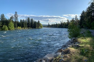
At the junction with the Ranger Hole Trail, take a left and follow it mostly downhill to the Duckabush River. Even in winter, verdant green covers the forest, providing a relaxing walk in all seasons. The final descent to the river is graveled and somewhat steep. About a mile from the trailhead, reach the first overlook of the river. Follow the trail around to arrive at the old fishing hole used by rangers past. The bright blue water flows fast through the tight rock gap, take care as the surface can be slippery.

Return the way you came, bypassing the turnoff to the Interrorem Trail on the way back. 

WTA Pro Tip: Make a day of it and visit the short Murhut Falls trail just 10 minutes down the road.

Hike Description Written by
Jessica Wynne, WTA Correspondent

Ranger Hole - Interrorem Nature Trail

Map & Directions

Trailhead
Co-ordinates: 47.6814, -122.9944 Open in Google Maps

Before You Go

See weather forecast

Parking Pass/Entry Fee

Northwest Forest Pass

WTA Pro Tip: Save a copy of our directions before you leave! App-based driving directions aren't always accurate and data connections may be unreliable as you drive to the trailhead.

Getting There

From Quilcene: Take Hwy 101 south for 15.4 miles. Turn right onto Duckabush Road and follow for 3.6 miles. The parking area is on your left.

From Hoodsport: Take Hwy 101 north for 21.7 miles. Turn left onto Duckabush Road and follow for 3.6 miles. The parking area is on your left.

The parking area has space for about 10 vehicles. There is no camping allowed at the trailhead, and there are no trash receptacles. A privy is located next to the trail just past the information sign.

More Hike Details

Trailhead

Olympic Peninsula > Hood Canal

Ranger Hole (#824), Interrorem Nature (#804)

Olympic National Forest, Hood Canal Ranger District

Guidebooks & Maps

Day Hiking: Olympic Peninsula (Romano - Mountaineers Books)

Best Hikes with Kids: Western Washington & the Cascades (Burton - Mountaineers Books)

Custom Correct The Brothers-Mount Anderson

You can improve or add to this guidebook entry!

Ranger Hole - Interrorem Nature Trail

93 Trip Reports

Hiked here recently?

Submit a trip report!
 
Trip Reports